
Articles
A Coastal Highway Re-routed by Presidential Fiat – Abdul Mahmud

By Abdul Mahmud
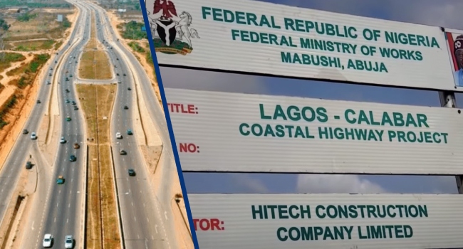
A highway is not a line drawn on a presidential map, it is a work of engineering, founded on surveys, geological investigations, hydrological evidence, environmental assessments and calculations that must withstand scrutiny long after those who commissioned it have left office. The controversy surrounding the Lagos-Calabar Coastal Highway now raises a question that the Federal Government cannot answer with presidential authority or ministerial assurances: by what scientific and statutory process has the route been changed? On 11 October, the Minister of Works, David Umahi, disclosed that President Bola Tinubu had directed the continuation of the highway from Ondo State into Edo State to follow the existing East-West Road. Umahi defended the separate realignment of the Ondo section by citing pits exceeding 100 metres in depth, unsuitable construction material and the prohibitive cost of traversing the original alignment.
He also invoked flooding and climate change to justify raising sections of the East-West Road. His explanations may contain legitimate engineering considerations; but legitimacy, however, cannot be established by the authority of the people advancing them. It must be demonstrated through evidence available for independent engineering examination.
Questions concern the Environmental and Social Impact Assessment (ESIA). What route did the assessment evaluate? What geological and hydrological evidence informed its conclusions? Which communities, wetlands, waterways, settlements and livelihoods were identified as potentially affected? Most importantly, does the assessment cover the newly proposed alignment, or does the Federal Government intend to proceed on the strength of an assessment prepared for a materially different route?
An environmental assessment is not a ceremonial document to be completed before construction and forgotten when political or financial considerations change; its purpose is to identify foreseeable harm, compare alternatives and establish measures for avoiding, reducing, or remedying adverse consequences. A substantial change in alignment raises questions about whether the original findings and mitigation measures remain valid.
Nigerians deserve a clear answer from the Federal Ministry of Environment and the Ministry of Works, supported by the relevant documents.
The ESIA document for Section One, covering approximately 47.5 kilometres, which has earlier been published by the Federal Government, demonstrates the existence of an assessment for that particular section; it does not establish that every subsequent section, or every revised alignment, has been adequately assessed, does it? The Government must disclose the assessments applicable to the disputed Ondo State corridor and the proposed continuation through Edo State and the Niger Delta. The second question concerns engineering science.
Minister Umahi says the original Ondo State alignment encountered extraordinary geological obstacles and that a detour was necessary. If the evidence supports that position, the Government should publish the comparative geotechnical investigations, route surveys, engineering designs, quantities of earthworks, bridge requirements and cost estimates for the original and revised alignments. Independent engineers should be able to determine whether the new route offers demonstrable advantages in safety, durability, cost and environmental performance.
The issue here is not whether a government may redesign a highway. Of course it may. Engineering designs are revised when field investigations expose conditions that were inadequately understood or when new evidence makes an alternative preferable. The issue is whether the decision followed a documented technical process or whether engineering has been reduced to a justification supplied after a political directive. The President may determine national infrastructure priorities; but he cannot make geological conditions disappear by decree, and a minister cannot turn a route into the most economical option simply by declaring it so. Presidential authority establishes no substitute for comparative analysis. Ministerial confidence is no substitute for independently verifiable calculations.
But, there is the more fundamental third question which interrogates the meaning of a coastal highway. Nigerians were presented with an ambitious corridor connecting Lagos to Calabar through the coastal states. The route was supposed to open communities, improve movement and strengthen economic connections along the coast. But, communities in Ilaje, Ondo State, now contest the reported departure from the original coastal alignment. The ethnic organisation, Ilaje Omuro Community Connect, has demanded an independent engineering assessment, comparative cost audit, and publication of the relevant project documents.
The demands of the Ilajes deserve a substantive response.
A route change which is justified by difficult terrain may redistribute economic opportunities, alter access to waterways and settlements, expose different communities to construction impacts, and change the environmental costs of a project. Such consequences must be measured rather than assumed away. The question isn’t about coastal communities having highways pass through their territories, it is about proper evaluation of alternatives and transparent explanation as to why selected routes best serve a road project’s stated objectives. The latest ministerial announcement concerning the East-West Road makes this scrutiny even more urgent. If the coastal highway is to share or follow existing road corridors through parts of the Niger Delta, the Government must publish a revised master alignment showing where the new highway departs from the original route, where it joins existing infrastructure, and how the different sections will connect towards Calabar. Nigerians should not have to reconstruct a national infrastructure project from ministerial briefings.
There is a further public-finance question. What is the comparative cost of the original and revised routes? How much has already been spent on surveys, design and preparatory work that may no longer serve their original purpose? What additional expenditure will the realignment require, and what independent process will verify the projected savings? The public purse cannot be asked to finance successive decisions while the evidence supporting them remains inaccessible. The Federal Government should publish the original and revised route maps, applicable ESIAs, geotechnical and hydrological studies, comparative cost estimates and the technical approvals authorising each material change.
The National Assembly should examine the decisions and commission an independent engineering review.
The Lagos-Calabar Coastal Highway is too consequential to be governed by presidential fiat and ministerial assurance. A coastal superhighway purposed to connect the country must first be founded on a process that connects public power to evidence, expenditure to accountability and development to the rights of the people expected to bear its costs.
Engineering science must determine the route. Presidential power isn’t the science, nor the evidence.
Full stop.

For publication of your news content, articles, videos or any other news worthy materials, please send to newsleverage1@gmail.com. For more enquiry, please call +234-901-067-1763 or whatsapp +234-901-067-1763. To place an advert, please call 09010671763



A Coastal Highway Re-routed by Presidential Fiat – Abdul Mahmud

Who is Really Governing Nigeria: President Tinubu or Minister Wike? – Otunba Babatunde Olushola Senbanjo Asks

“We Have Tried Orji Kalu; Now Try Someone Else” – Bourdex Tells Bende Monarchs

Facebook Dispute: Rt. Hon. Ochei Campaign Council Demands Immediate Release of Detained Aide

Fuel Discount: ‘We Are Not Dumb to Give Nigerians One-Month Discount for Votes’ – Oyedele

Cardinal Onaiyekan: Governor Alia Was Suspended for Defying Catholic Church Rules on Politics

Oshiomhole Clashes With Interviewer Who Questioned Why He Protested Fuel Price Under Obasanjo But Never Under Tinubu

30-Day Fuel Discount: Nigerians Deserve More Than Temporary Relief – Otunba Babatunde Olushola Senbanjo

FG Announces 30-Day Petrol Discount at NNPC Stations

Orji Mourns Squadron Leader Man-Ugwueje, Describes Fallen Air Force Officer as Servant of Fatherland

Ikeji Aro 2026 on Avor Osu Day: Nkita Oku, Inum, Ekpe Erim, Other Ekpo Masquerades Pay Homage to Eze Eberechukwu Oji

97-Year-Old Dr Mrs. Shields Reconstructs, Reopens Mary Slessor Library in Arochukwu

Ikeji-Aro 2026: ‘We Are Repackaging Aro Traditional Healing Practices for the Younger Generation’ – Mazi Ernie Onwumere

2027: Hon. Ike Bishop Okoronkwo Mobilises Abia North Grassroots, Tasks ADC Coordinators on Polling Units

Eze Eberechukwu Oji Commissions Amuvi Community Self-Built Connectivity Hub

APC Sanctuary: How the Ruling Party Became Nigeria’s Governance Virus – Otunba Babatunde Olushola Senbanjo

Nigeria Owes Tobi Amusan a Statue – Abdul Mahmud

Obioma-Ngwa 2027: Chidi Nnamdi Pushes Case for Responsive Representation – Comrade Abuchi Isaac

‘We Will, We Will, We Will’: Atiku Slams Tinubu Over Promises, Questions Achievements After Three Years

Leave Chidi Nnamdi Alone, Earn the People’s Trust – New Direction Agenda

The final 6 ‘Game of Thrones’ episodes might feel like a full season
New Season 8 Walking Dead trailer flashes forward in time
Mod turns ‘Counter-Strike’ into a ‘Tekken’ clone with fighting chickens
Meet Superman’s grandfather in new trailer for Krypton
Disney’s live-action Aladdin finally finds its stars
Who are the early favorites to win the NFL rushing title?
The old and New Edition cast comes together to perform
Boxing continues to knock itself out with bewildering, incorrect decisions
Steph Curry finally got the contract he deserves from the Warriors
Phillies’ Aaron Altherr makes mind-boggling barehanded play
-
 Abia State News3 weeks ago
Ikeji Aro 2026 on Avor Osu Day: Nkita Oku, Inum, Ekpe Erim, Other Ekpo Masquerades Pay Homage to Eze Eberechukwu Oji
-
 Abia State News2 weeks ago
97-Year-Old Dr Mrs. Shields Reconstructs, Reopens Mary Slessor Library in Arochukwu
-
 Abia State News4 weeks ago
Ikeji-Aro 2026: ‘We Are Repackaging Aro Traditional Healing Practices for the Younger Generation’ – Mazi Ernie Onwumere
-
 POLITICS2 weeks ago
2027: Hon. Ike Bishop Okoronkwo Mobilises Abia North Grassroots, Tasks ADC Coordinators on Polling Units
-
 Abia State News2 weeks ago
Eze Eberechukwu Oji Commissions Amuvi Community Self-Built Connectivity Hub